Maps and plans for a landscape archeology
We follow in the footsteps of the Independence Bicentennial for a look at the maps and plans of the Panamanian […]
We follow in the footsteps of the Independence Bicentennial for a look at the maps and plans of the Panamanian territory generated in the 19th century, which offer a very interesting opportunity to interpret the dimensions of the cultural construction of the landscape and the territory. We explore the visions around the cultural landscape, cartography and anthropology, in the voice of Carlos Fitzgerald, a specialist interested in these topics, of what at some point, we call interoceanity.
What do we understand by interoceanity in reference to the landscape and the Canal?
Twenty-five years ago, we talked about interoceanity in the conceptual proposal of the inaugural exhibition of the Interoceanic Canal Museum, which was developed in three thematic axes: “The route, the water and the people” (O. Acosta, C. Fitzgerald and H. Vélez, 1996). The concept was later developed by Ana Elena Porras in Cultura de la interoceanidad (2009).

Our proposal addressed the narrative about this landscape that evolved over centuries and we note how technological innovations overlap, while geopolitical interests intersect, leaving profound changes in the demographic footprint derived from internal and external migrations. Territory, people and the route construct the cultural landscape of the transit space, where cartography is key to its interpretation.
What role do maps and plans play in interpreting the cultural landscape?
Cultural landscapes are a category of heritage-cultural conceptualization particularly interesting for the Panamanian interoceanic region, which is configured as a classic example of complex cultural landscape, where it is possible to read layers of intervention by a diversity of human groups, with different technologies, concatenated some with local historical and ethnographic processes, and others with Immanuel Wallerstein’s world-systems. To understand the cultural landscape, we must consider the context. From this perspective, we can approach the Isthmian cartographic heritage in a creative way, detached from geography itself, and recognizing unsuspected anthropological qualities in the maps and plans. The detailed comparative analysis of the cartography is useful for an archaeology of the cultural landscape, where settlement patterns and the use of resources are reflected: The maps and plans of the interoceanic region not only express the reality of the landscape, but also the desires and illusions of those who, on the one hand, exercised control over the territory and its people and, on the other, of those who dreamed of transforming it.
What are the main maps and plans produced in the 19th century?
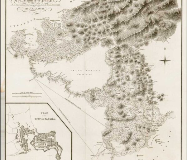
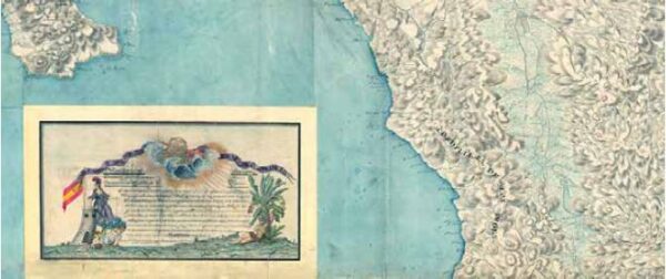
All the cartography produced in the 19th century came from the hand of those who were interested in the construction of an inter-oceanic communication. In Panama City, the last map of the Viceroyalty of New Granada signed by Vicente Talledo y Rivera (he arrived as a war refugee to the last royalist bastion shortly before independence, so his map reflects the legacy of Spain) was produced in 1815. The second important and first post-independence map is generated in 1829, commissioned by Simón Bolívar after the Amphictyonic Congress of Panama to John Lloyd and Maurice Falmarc, to determine the best route for a canal. Limon Bay was chosen as the Atlantic terminus with a mixed water route with the Chagres River and another overland section with a train and two possible routes to Panama City and another closer to La Chorrera. Lloyd’s map is a precursor of the interoceanic railroad.
For the final alignment of the iron road, completed in 1855, the well-known Harrison map of 1857 (mapped by the engineer George M. Tottem, which shows the as-built alignment between the Panama and Colon terminals) appears.
Tottem worked on the cartography of Napoleon Garella (1845) and George W. Hughes (1849) as Hernán Araúz points out in his publication Los mapas antiguos de Panamá y Darién (2016). It should be noted that, simultaneously to the North American explorations, Agustín Codazzi carried out in Panama the detailed studies of the Corographic Expedition ordered by General Tomas Cipriano de Mosquera, whose purpose was to have an instrument that would allow the administration of the vast territories of Colombia and to highlight the Department of the Isthmus as an object of study.
In the period between the completion of the railroad and the beginning of the construction of the Canal, no less than 10 important maps were produced to define the best route. Key contributions were made by the expeditions of Wyse and Reclus, French explorers who carried out the task of describing the route through the Darien (1877), as a mandate of the Canal Congress, at the invitation of the Paris Geographical Society, thus determining the current Canal landscape.
What is the importance of the production of all this cartographic material?
These maps were drawn by hands, by feet that walked and eyes that looked at the territory with the illusion of communicating the seas. Since the Gold Rush and the construction of the railroad between 1850 and 1855, the transformations of the interoceanic landscape are reflected in the maps. Historical cartography expresses the expectations of its makers, from political control to the exploitation of economic resources. This is the case of Panama, where the fundamental strategic resource is the geographic position and the information to facilitate, or not, the communication between two seas. The maps of the route of the railroad, first and later, of the Canal, establish what would become the Canal Zone when the U.S. imperial project was consolidated.
Are these maps important to understand the evolution of the territory?
Cartographic analysis of the maps of the interoceanic region produced in the 1840s, 1850s, 1870s and 1890s allows us to recognize some repeating patterns and contrast the different perspectives in a time series that is a luxury for the researcher, as we can identify changes, continuities, innovations and omissions that shed light, not only on political and economic interests, but also on the construction of a landscape that, at the same time, is known center and periphery, but also with gaps. Depending on the nationality of the cartographer and the geopolitical interests he represents, each map emphasizes different things, even though it is the same landscape: the variants of the route, the populated places, the associated production areas and above all, the names that tell us about the local populations, the migrant populations that leave their mark and the symbolic uses of the official nomenclature to denote power and control. The analysis of maps in the second half of the 19th century is a valuable source of information for understanding the progressive shaping of the interoceanic landscape. The urban maps of Panama and Colon in the times of the railroad and the French Canal, where we see the land speculation and the creation of novel schemes of colonial and neo-colonial coexistence, are invaluable sources for all types of research and keys to talk about the phenomena of settlement, economy and politics of the Canal enclave, which eventually excluded from the landscape centuries-old settlements and erased, as the Panamanian historian Marixa Lasso points out, a part of history.

Can we then speak of a cartographic heritage?
The archaeology of the cartographic series of the transit region tells us about instruments that organized and marked the forms of how our ancestors inhabited this interoceanic region, to which today we assign the name of transitism. They are spaces and names of the present, both when we access and when we use the spaces to move, work/produce or for leisure. They are all part of that historical cartographic heritage, inherited and assumed. Furthermore, the ways in which we imagine ourselves in the landscape, as owners or guests, whether we feel alien or rejected, have nuances in the cartography and should be the subject of deeper anthropological studies to elucidate our very Panamanian ways of belonging and being, which are not necessarily transitive or subordinate, but creative and resilient.